Welcome to the AGL Data Portal, a one stop location for all information about all AGL datasets.
Given below are the various sections in this page:
- Copyrights, contracts and constraints: Information about the confidentiality agreements.
- Data list:
- Frequently Asked Questions: Common frequently asked questions.
For any questions regarding this page please mail to lchang13@uh.edu.
Copyrights, contracts and constraints
The datasets listed here are either owned / controlled by AGL or are licensed for use (with constraints). When data are licensed to the AGL, then the ownership and control of the data are held by an entity, outside of the University. The data owner supplies a contract (a.k.a. 'license agreement') defining the terms on which we must conform, in order to gain use of the data for research. All student/staff researchers are required to adhere to the license agreements placed by the data owners (explained in "Levels 1 thru 3" below).
Level 4: Data was acquired by UH EAS group and will be released publically upon request.
Level 3: Data which is accessible by all AGL members. It can be freely copied and distributed between student researchers and publication sources. Examples of this are from the YBRA Field Camps, as the data are acquired by UH Students & Staff for use by the same. Examples include all data acquired by AGL field crew.
Level 2: This data is restricted. This is data is owned by another company and a "license" has been issued to UH for limited use. Typically, the data may be used for independent research, but copy and distribution are not permitted without the express written permission of the data owner. Please refer to specific contract documents before requesting a copy of this data. The data owners have indicated some flexibility in permitting the publication of their data, but an approval process has to be followed.
Level 1: This data is strictly confidential. These datasets are distinctly not owned by UH / AGL, and a license to use it has been expressly defined. By agreement with the owner, the research data cannot be copied, distributed, published, sold, traded or otherwise disclosed in any way without the expressed written authorization from the data owner. There are datasets where the data owner specifies that the students must apply in writing that they have reviewed and understand the terms of confidentiality, before they can work with the data. Derivative products such as reprocessing and interpretations are also subject to the same restrictions and confidential treatment is required. NO DISTRIBUTION IS PERMITTED WITHOUT WRITTEN PERMISSION.
Please bear in mind that this is a professional and ethical issue of greatest importance, which must be adhered to without exception. The reputation of our institution is at stake, as well as that of the Researcher. There can be legal consequences to the abuse of licensed data.
Violation of the terms of this agreement could result in the expulsion from this academic program.
Data List
Note: The location information on the map and the location resources below are just approximation, and is not accurate. This is done because of the various contractual obligations.
Map View
Please click on the tag in the map to get more information about the data.
View AGL Data Location Alfa in a larger map
The see the above map in google maps, click here.
List View
Note: This list is a living document. We continue to update with more information as it becomes available.
Click to expand each topic below.
Haitian Lakes Chirp Sonar Survey 2014
Haiti 2014
General:
Location: Lake Azuey and Lake Miragoâne, Haiti
Location Resource:
Date: Aug, 2014
Data Summary: High frequency chirp sonar data
Contact Professor: Dr. Robert R. Stewart
License and Constraints:
Contributor:
Company: Allied Geophysical Laboratories
Website: www.agl.uh.edu
Survey Description:
This survey was acquired in the country of Haiti. The sonar profile covers total of 94 km high-resolution profiles from Lake Azuey and 37 km of profiles from Lake Mirogoâne. The frequency range was set as 2 - 15 kHz. The shot rate is 1/4 per second. The data was collected with Edge Tech 216i subbottom profiler.
Data Location:
Available on the AGL Datastation:
Galveston-San Luis Pass 2017
Galveston-San Luis Pass 2017
General:
Location: San Luis Pass, TX, USA
Location Resource: Google Maps
Date: 2017
Data Summary: Chirp Seismic
Contact Professor: Dr. Julia S. Wellner
License and Constraints: Level 4
Contributor:
Company: University of Houston
Website: http://www.uh.edu/nsm/earth-atmospheric/
Survey Description:
Fourteen lines of Chirp data acquired in the San Luis Pass area with a total length of 65 km. The San Luis Pass is a tidal inlet located in the Texas Gulf Coast at the southwest end of the Galveston area, approximately 80 km south of Houston, Texas, and 32 km southwest of the city of Galveston. San Luis Pass separates Galveston and Follets islands. High-resolution data with a maximum penetration of ~25 m.
Data Location:
Once you have got permission from the 'Contact Professor', please contact lchang13@uh.edu for access.
Publications with data:
Ph.D. dissertation of Carolina Ramon, expected 2019
Apollo Lunar Seismic Data - Seismic - Moon
Apollo Lunar Seismic Data
General:
Location: Moon
Location Resource: Google Maps
Date:
Data Summary: Seismic
Contact Professor: Dr. Robert R. Stewart
License and Constraints: Level 3 - Limited
Contributor:
Company: NASA
Website: www.nasa.gov
Survey Description:
Data was obtained from the Apollo 14 (thumper source), Apollo 16(using thumper and rocket propelled grenade) and Apollo 17(explosive package). In the experiments 3 geophones where used on Apollo 14 and 16 and four on Apollo 17.
Data Location:
Available on the AGL Datastation: http://datastation.agl.uh.edu. Once you have got permission from the 'Contact Professor', please contact lchang13@uh.edu for access.
Arizona(Barringer) Meteor Crater 2010 - Seismic, GPR, Gravity, Magnetic - Near Winslow, AZ, USA
Arizona (Barringer) Meteor Crater 2010
General:
Location: Near Winslow, Arizona, USA
Location Resource: Google Maps
Date: 05/17/2012 - 05/20/2010
Data Summary: Seismic, GPR, gravity and magnetic surveys were conducted. Seismic Source1 (10-lb Hammer) for Seismic refraction Seismic Source2 (Accelerated Weight Drop) for Seismic refraction and near-surface reflections
Contact Professor: Dr. Robert R. Stewart
License and Constraints: Level 3 - Limited
Contributor:
Company: Allied Geophysical Laboratories
Website: www.agl.uh.edu
Survey Description:
Seismic: Seismic data were acquired - i) along 5 small lines using 10-lb hammer and ii) along one 645 m long line using Accelerated Weight Drop. Gravity data were collected along 5 lines and magnetic data were collected along 4 lines.
GPR: Two swaths of 100 m x 4.5 m each, one cross-line of 4.5 m x 10 m and another cross-line of 10 m x 4.5 m using 250 MHz Noggin system.
Data Location:
Available on the AGL Datastation: http://datastation.agl.uh.edu. Once you have got permission from the 'Contact Professor', please contact lchang13@uh.edu for access.
BP Data Donation 2010 - Bathymetric Data, side scan sonar data and sub bottom profiler data - Gulf of Mexico
BP Data Donation 2010
General:
Location: Gulf of Mexico, USA
Location Resource: Google Maps
Date: 2010
Data Summary: Bathymetric data, side scan sonar data and sub bottom profiler data.
Contact Professor: Dr. Robert R. Stewart
License and Constraints: Level 2 - Confidential
Contributor:
Company: BP
Website: www.bp.com
Survey Description:
Contains high resolution seabed data covering Atlantis, Holstein, Mad Dog & Thunder Horse fields at Gulf of Mexico, USA.
Data Location:
Once you have got permission from the 'Contact Professor', please contact lchang13@uh.edu for access.
Bradford 3C3D - 3C3D Seismic - Bradford Counties, Pennsylvania, USA
Bradford 3C3D
General:
Location: Bradford Counties, Pennsylvania, USA
Location Resource: Google Maps
Date: 2009
Data Summary: 3C3D Seismic
Contact Professor: Dr. Robert R. Stewart.
License and Constraints: Level 2 - Confidential
Contributor:
Company: Geokinetics Inc.
Website: www.geokinetics.com
Company: Geophysical Pursuit, Inc.
Website: www.geopursuit.com
Survey Description:
Contains 3D3C data acquired from the Bradford counties in North Pennsylvania. The dataset contains the raw x, y and z components, radial and transverse components, raw PS1(fast) and PS2 (slow) components and velocity information.
Data Location:
Once you have got permission from the 'Contact Professor', please contact lchang13@uh.edu for access.
Energy Research Park 2011 - 2C2D Seismic - UH Energy Research Park, Houston, TX, USA
Energy Research Park 2011
General:
Location: UH Energy Research Park, Houston, TX, USA
Location Resource: Google Maps
Date: Aug, 2011
Data Summary: 2D2C(1 vertical and 1 in-line horizontal) Seismic
Contact Professor: Dr. Robert R. Stewart
License and Constraints: Level 3 - Limited
Contributor:
Company: Allied Geophysical Laboratories
Website: www.agl.uh.edu
Survey Description:
This survey was conducted at the Energy Research Park at the University of Houston. The line consisted of 96 vertical and 96 horizontal points with the horizontal geophones pointed along the direction of the line (in-line). The receiver interval was 3 meters. The receiver location was acquired using Leica total station.
The source used in the survey was the AGL mini vibroseis and the Propelled Energy Source. The source was shot in the middle of the geophones.
Data Location:
Available on the AGL Datastation: http://datastation.agl.uh.edu. Once you have got permission from the 'Contact Professor', please contact lchang13@uh.edu for access.
Haiti 2012 - 2D2C and Gravity - Leogane, Haiti
Haiti 2012
General:
Location: Leogane, Haiti
Location Resource: Google Maps
Date: Jan, 2012
Data Summary: 2D2C (1 vertical and 1 inline horizontal), Gravity
Contact Professor: Dr. Robert R. Stewart
License and Constraints: Level 3 - Limited
Contributor:
Company: Allied Geophysical Laboratories
Website: www.agl.uh.edu
Survey Description:
This survey was acquired in the country of Haiti. The seismic line consisted of 84 receiver location with receiver interval of 3 meters. During the experiment we used the vertical geophones first and then removed and replanted the horizontal geophones. The horizontal geophones where inline. The data was acquired using the stratavisor. The receiver location was found using the total station.
The source used in the experiment was hammer. The shots where taken between the receiver locations.
Data Location:
Available on the AGL Datastation: http://datastation.agl.uh.edu. Once you have got permission from the 'Contact Professor', please contact lchang13@uh.edu for access.
Haiti 2013-Seismic, Gravity - Leogane, Haiti
Haiti 2013
General:
Location: Leogane, Haiti
Location Resource: Google Maps
Date: Feb, 2013
Data Summary: Seismic 2D2C, GPR
Contact Professor: Dr. Robert R. Stewart
License and Constraints: Level 3 - Limited
Contributor:
Company: SEG - Geoscientist Without Borders
Website: www.seg.org
Company: Allied Geophysical Laboratories
Website: www.agl.uh.edu
Survey Description:
This expedition was organized by AGL as part of Geoscientists Without Borders. The aim was to image the proposed blind fault Leogaine (Haiti) fan. For this purpose we acquired a 5 Km vertical seismic receiver line with the wacker as the source. An additional 600 meter seismic line was acquired with horizontal receiver. We also surveyed the same area with gravity meter. Additional gravity lines were acquired at Pétionville area and from Jacmel to Léogâne city.
Data Location:
Available on the AGL Datastation: http://datastation.agl.uh.edu. Once you have got permission from the 'Contact Professor', please contact lchang13@uh.edu for access.
Hess Energy Red Sky - 3D3C Seismic - North Dakota, USA
Hess Energy Red Sky
General:
Location: North Dakota, USA
Location Resource: Google Maps
Date: 2009
Data Summary: 3C3D Seismic
Contact Professor: Dr. Robert R. Stewart.
License and Constraints: Level 2 - Confidential
Contributor:
Company: Hess Energy
Website: www.hess.com
Survey Description:
Contains 3D3C data acquired from Red Sky area, North Dakota
Data Location:
Once you have got permission from the 'Contact Professor', please contact lchang13@uh.edu for access.
Hockley Fault 2012 - Seismic, GPR, Gravity - Cypress, Houston, Texas, USA
Hockley Fault 2012
General:
Location: Cypress, Houston, TX, USA
Location Resource: Google Maps
Date: March, 2012
Data Summary: Seismic 1C2D (vertical component), GPR, Gravity
Contact Professor: Dr. Robert R. Stewart, Dr. Shuhab Khan
License and Constraints: Level 3 - Limited
Contributor:
Company: Allied Geophysical Laboratories
Website: www.agl.uh.edu
Survey Description:
The survey was carried out at the Hockley fault near the Houston Premium Outlet using the AGL Mini Vibe. The vertical geophone was used as receiver. Number of receiver points was 216 with receiver interval is 5 meters. The shot was done in between the receivers. The location was measured using GPS and Total Station.
GPR and Gravity measurement where also done at the location.
Data Location:
Available on the AGL Datastation: http://datastation.agl.uh.edu. Once you have got permission from the 'Contact Professor', please contact lchang13@uh.edu for access.
Jemez Pueblo 2010 - Seismic, Gravity - Jemez Pueblo, NM, USA
Jemez Pueblo, New Mexico 2010
General:
Location: Pueblo of Jemez Indian reservation in northern central New Mexico.
Location Resource: Google Maps
Date: 05/22/2010
Data Summary: Seismic and gravity surveys were conducted. Seismic Source1 (10-lb Hammer) for Seismic refraction Seismic Source2 (Accelerated Weight Drop) for Seismic refraction and near-surface reflections
Contact Professor: Dr. Robert R. Stewart
License and Constraints: Level 3 - Limited
Contributor:
Company: Allied Geophysical Laboratories
Website: www.agl.uh.edu
Survey Description:
Seismic data were acquired - i) along one 141 m long line using 10-lb hammer and ii) along one 475 m long line using Accelerated Weight Drop. The gravity line was 1440 m long and almost along seismic line.
Data Location:
Available on the AGL Datastation: http://datastation.agl.uh.edu. Once you have got permission from the 'Contact Professor', please contact lchang13@uh.edu for access.
Katy Mammoth 2013 - GPR - Katy, TX, USA
Katy Mammoth 2013
General:
Location: Near Katy, Texas
Location Resource: Google Maps
Date: Mar, 2013
Data Summary: GPR
Contact Professor: Dr. Robert R. Stewart
License and Constraints: Level 3 - Limited
Contributor:
Company: Allied Geophysical Laboratories
Website: www.agl.uh.edu
Survey Description:
GPR surveys were conducted at a Mammoth bone site near Katy, TX. Survey grids using 250 MHz and 1 GHz antennas were acquired over a sand terrace adjacent to the excavation pit. The survey results will guide the ongoing excavation of buried bones. Survey lines also were acquired to determine the lateral extent of the sand package away from the bone site. Finally, a Total Station survey of the survey grid and the bones in the excavation pit was performed.
Data Location:
Once you have got permission from the 'Contact Professor', please contact lchang13@uh.edu for access.
La Marque 2010 - Seismic, GPR - La Marque, TX, USA
La Marque 2010
General:
Location: La Marque Geophysical Observatory, Near Galveston, Texas
Location Resource: Google Maps
Date: 03/18/2010 - 03/19/2010 and 03/28/2010
Data Summary: Seismic and GPR surveys were conducted. Seismic Source1 (10-lb Hammer) for Seismic refraction Seismic Source2 (Accelerated Weight Drop) for Seismic refraction and near-surface reflections
Contact Professor: Dr. Robert R. Stewart
License and Constraints: Level 3 - Limited
Contributor:
Company: Allied Geophysical Laboratories
Website: www.agl.uh.edu
Survey Description:
Seismic data were acquired - i) along 4 small lines using 10-lb hammer and ii) along one 360 m long line using Accelerated Weight Drop.
Data Location:
Available on the AGL Datastation: http://datastation.agl.uh.edu. Once you have got permission from the 'Contact Professor', please contact lchang13@uh.edu for access.
La Marque 2012 - Seismic, Gravity, GPR - La Marque, TX, USA
La Marque, 2012
General:
Location: UH Coastal Center, La Marque, Texas, US
Location Resource: Google Maps
Date: 03/03/2012 - 03/04/2012
Data Summary: 2D Vertical Seismic, Gravity, GPR
Contact Professor: Dr. Robert R. Stewart
License and Constraints: Level 3 - Limited
Contributor:
Company: Allied Geophysical Laboratories
Website: www.agl.uh.edu
Survey Description:
The survey was carried out at the UH Coastal Center, La Marque, Houston, TX. The seismic consisted of a 2D line with 192 vertical geophones with 5 meter receiver interval(line length 960 meters). The source used in the experiment was AGL mini vibroseis. The location of the geophones was tracked using the Leica Total Station.
Gravity and GPR was also run along the line of the receiver.
Data Location:
Available on the AGL Datastation: http://datastation.agl.uh.edu. Once you have got permission from the 'Contact Professor', please contact lchang13@uh.edu for access.
Marathon Fort Worth Seismic and Well Data - 3D Seismic, Well logs, Micro seismic, Core Analysis - Fort Worth Basin, TX, USA
Marathon Fort Worth Seismic and Well Data
General:
Location: Fort Worth Basin Seismic, Texas, USA
Location Resource: Google Maps
Date:
Data Summary: 3D Seismic, Well logs, Micro seismic, Core Analysis
Contact Professor: Dr. Robert R. Stewart, Dr. John Castagna
License and Constraints: Level 1 - Very Confidential
Contributor:
Company: Marathon Oil Corporation
Website: www.marathonoil.com
Survey Description:
Contains field data, processed gathers, stacked volumes, and support information for Harris and Gleason 3D1C Surveys in Hamilton County, Texas. Various well logs from Duncan Ranch Wells, James Duncan Well, Lake Davis Well and Mesquite well are available. Micro seismic and core analysis data are also provided.
Data Location:
Once you have got permission from the 'Contact Professor', please contact lchang13@uh.edu for access.
Marcellus ( Bradford County) Logs - Well logs - PA, USA
Marcellus (Bradford County) Logs
General:
Location: Bradford county, Pennsylvania, USA
Location Resource: Google Maps
Date: 2012
Data Summary: Well logs
Contact Professor: Dr. Robert R. Stewart
License and Constraints: Level 3 - Limited
Contributor:
Company: Anadarko Petroleum Corporation
Website: www.anadarko.com
Survey Description:
Contains well log data from Bradford county. Logs include caliper, density, sonic log, shear sonic, Gamma, Neutron Porosity, PEF, and resistivity.
Data Location:
Once you have got permission from the 'Contact Professor', please contact lchang13@uh.edu for access.
Marmousi II Dataset - Numerical Model - TX, USA
Marmousi II Dataset
General:
Location: Allied Geophysical Laboratory
Location Resource: Google Maps
Date:
Data Summary: Numerical Model
Contact Professor:
License and Constraints: Level 3 - Limited
Contributor:
Company: Allied Geophysical Laboratories
Website: www.agl.uh.edu
AGL would like to acknowledge Gary S. Martin, Dr Robert Wiley and Kurt J. Marfurt
Survey Description:
The data is the updated and upgraded Marmousi model and data set. Please see the TLE article below for more information.
Data Location:
You can download the data at http://sheriff.agl.uh.edu/ftp/outgoing/Marmousi%20Data
Montana Field Camp (YBRA) 2010 - 2D2C, 2D3C, Well Logs, VSP, Crosswell, GPS, GPR, Gravity, Magnetic - Red Lodge, MT, USA
Montana Field Camp (YBRA) 2010
General:
Location: Yellowstone Bighorn Research Association Camp and Surrounding Areas, Red Lodge, MT, USA
Location Resource: Google Maps
Date: July - Aug 2010
Data Summary: Seismic 2D2C, Seismic 2D3C, Well Logs, VSP, Crosswell, GPS, GPR, Gravity, Magnetic
Contact Professor: Dr. Robert R. Stewart
License and Constraints: Level 3 - Limited
Contributor:
Company: Allied Geophysical Laboratories
Website: www.agl.uh.edu
Survey Description:
Eight separate full day experiments were held. There were 4 activities per day.
Data Location:
Available on the AGL Datastation: http://datastation.agl.uh.edu. Once you have got permission from the 'Contact Professor', please contact lchang13@uh.edu for access.
Montana Field Camp (YBRA) 2011 - 2D2C, 2D3C, Well Logs, VSP, Crosswell, GPS, GPR, Gravity, Magnetic - Red Lodge, MT, USA
Montana Field Camp (YBRA) 2011
General:
Location: Yellowstone Bighorn Research Association Camp and Surrounding Areas, Red Lodge, MT, USA
Location Resource: Google Maps
Date: July - Aug 2011
Data Summary: Seismic 2D2C, Seismic 2D3C, Well Logs, VSP, Crosswell, GPS, GPR, Gravity, Magnetic
Contact Professor: Dr. Robert R. Stewart
License and Constraints: Level 3 - Limited
Contributor:
Company: Allied Geophysical Laboratories
Website: www.agl.uh.edu
Survey Description:
Eight separate full day experiments were held. There where 4 activities per day.
Data Location:
Available on the AGL Datastation: http://datastation.agl.uh.edu. Once you have got permission from the 'Contact Professor', please contact lchang13@uh.edu for access.
Montana Field Camp (YBRA) 2012 - 2D2C, 2D3C, Well Logs, VSP, Crosswell, LiDAR, GPS, GPR, Gravity, Magnetic, Broadband - Red Lodge, MT, USA
Montana Field Camp (YBRA) 2012
General:
Location: Yellowstone Bighorn Research Association Camp and Surrounding Areas, Red Lodge, MT, USA
Location Resource: Google Maps
Date: 07/29/2012 - 08/09/2012 (JD 213-221)
Data Summary: Four activities were conducted each day. Instructors are listed to the right of each activity. Reflection and refraction seismic data are in SEGY format, with borehole seismic measurements in SEGY of SEG2 formats.
LG (LiDAR and GPS) - Bob Wang and UNAVCO
G (gravity, magnetic, total station) - Stuart Hall, Kevin Schmidt
S1 (Seismic refraction: whackers) - Kyle Spikes, Anoop William
S2 (Seismic reflection: vibe) - Jeff Sposato, Bart Hoekstra, Li Chang, Ady Geda
P (GPR) - Kevin Schmit, Susan Green
V (well logging, VSP, xwell) - Anoop William, Jeff Sposato, Rob Stewart
S3 (Seismic reflection: vibe ) - Kyle Spikes, Li Chang, Ady Geda
S4 (Broadband, VMeter, Blastmate) - Bob Wang, Rob Stewart
Contact Professor: Dr. Robert R. Stewart
License and Constraints: Level 3 - Limited
Contributor:
Company: Allied Geophysical Laboratories
Website: www.agl.uh.edu
Survey Description:
Eight separate full day experiments were held. Each activity was repeated 4 times, by 4 groups of participants. File names are designated by Julian Day of activity (JD 213 - 216 or JD 218 - 221) plus Group identifier (G1 - G4). OB logs & positioning performed by student participants.
Data Location:
Available on the AGL Datastation: http://datastation.agl.uh.edu. Once you have got permission from the 'Contact Professor', please contact lchang13@uh.edu for access.
Montana Field Camp(YBRA) 2013-2D2C, 2D3C, Well Logs, VSP, GPR, Gravity, Magnetic, -Red Lodge, MT, USA
Montana Field Camp (YBRA) 2013
General:
Location: Yellowstone Bighorn Research Association Camp and Surrounding Areas, Red Lodge, MT, USA
Location Resource: Google Maps
Date: 08/05/2013 - 08/16/2013
Data Summary: Four activities were conducted each day. Instructors are listed to the right of each activity.
LG (LiDAR and GPS) - Bob Wang and UNAVCO
G (gravity, magnetic, total station) - Eray Kocel, Rob Stewart
S1 (Seismic refraction: impulse) - Kyle Spikes, Anoop William
S2 (Seismic reflection: vibe) - Jeff Sposato, Li, Ady
P (GPR) - Eray Kocel, Long Huang
V (well logging, VSP, xwell) - Anoop William, Rob Stewart
S3 (Seismic reflection: vibe ) - Spikes, Li, Ady Geda
S4 (Broadband, VMeter, Blastmate) - Bob Wang, Rob Stewart
Contact Professor: Dr. Robert R. Stewart
License and Constraints: Level 3 - Limited
Contributor:
Company: Allied Geophysical Laboratories
Website: www.agl.uh.edu
Survey Description:
Eight separate full day experiments were held. Each activity was repeated 4 times, by 4 groups of participants.
Data Location:
Available on the AGL Datastation: http://datastation.agl.uh.edu. Once you have got permission from the 'Contact Professor', please contact lchang13@uh.edu for access.
Needville Fault 2012 - 2D1C Seismic data, Gravity - Needsville, TX, USA
Needville Fault 2012
General:
Location: Needville, TX, USA
Location Resource: Google Maps | KMZ
Date: 2012
Data Summary: 2D1C Seismic
Contact Professor: Dr. Robert R. Stewart
License and Constraints: Level 3 - Limited
Contributor:
Company: Allied Geophysical Laboratories
Website: www.agl.uh.edu
Survey Description:
The primary objective of this field camp was to study a fault in the region. We had 192 receiver stations with 5 meter interval. The source used was the AGL minivib. Please see the kmz for geometry.
We also had acquired the gravity reading along the same line.

Data Location:
Once you have got permission from the 'Contact Professor', please contact lchang13@uh.edu for access.
North Dakota Oil and Gas Division - Subscription Service - ND, USA
North Dakota Oil and Gas Division
General:
Location: North Dakota, USA
Location Resource: Google Maps
Date:
Data Summary: A list of service we have subscribed to is available at https://www.dmr.nd.gov/oilgas/subscriptionservice.asp
Contact Professor: Dr. Robert R. Stewart
License and Constraints: This is an external service. Need to follow the conditions set by them.
Contributor:
Company: North Dakota Oil and Gas
Website: www.dmr.nd.gov/oilgas/
Survey Description:
A list of service we have subscribed to is available at https://www.dmr.nd.gov/oilgas/subscriptionservice.asp
Data Location:
Once you have got permission from the 'Contact Professor', please contact lchang13@uh.edu for access.
PGS FlexR III - 3D Seismic - Gulf of Mexico
PGS FlexR III
General:
Location: Gulf of Mexico
Location Resource: Google Maps
Date:
Data Summary: 3D Seismic
Contact Professor: Dr. Paul Mann, Dr. Robert R. Stewart
License and Constraints: Level 1 - Very Confidential
Contributor:
Company: Petroleum Geo-Services
Website: www.pgs.com/
Survey Description:
PGS' FlexR III reprocessing project provides an updated inventory of detailed 3D seismic imaging over the Flex Trend - data that are ideal for deep objectives. Imaging at depth, enhanced fault definition, and better salt and subsalt imaging are achieved through detailed velocity modeling and true amplitude, bending-ray Kirchhoff prestack time migration.
The data includes:
- 3D Kirchhoff prestack time migration January 2004
- 48-fold prestack time migrated gathers
- Velocity model
- Angles stacks
- Offset stacks
Data Location:
Once you have got permission from the 'Contact Professor', please contact lchang13@uh.edu for access.
Pierce Junction 2011 - 2D2C, Gravity - Pierce Junction, TX, USA
Pierce Junction 2011
General:
Location: Pierce Junction, TX, USA
Location Resource: Google Maps
Date: 2011
Data Summary: Seismic 2D2C, Gravity
Contact Professor: Dr. Robert R. Stewart
License and Constraints: Level 2 - Confidential
Contributor:
Company: Texas Brine Corporation
Website: www.texasbrine.com
Company: Allied Geophysical Laboratories
Website: www.agl.uh.edu
Survey Description:
This 2D2C data was acquired by AGL at Pierce Junction. The line was deployed at 595meters in the beginning and then we rotated the first 360 to the end so as to get a total length of 955. The receiver interval was 5 meters. The receiver location was surveyed using total station and GPS.
The source used was the AGL mini vibroseis.
Data Location:
Once you have got permission from the 'Contact Professor', please contact lchang13@uh.edu for access.
RMOTC Dataset-Well Log, Core Data, Seismic, GIS Data - Leogane, Haiti
RMOTC Datasets
General:
Location:
Location Resource: Google Maps
Date: Feb, 2013
Data Summary: Seismic 2D2C, GPR
Contact Professor: Dr. Robert R. Stewart
License and Constraints:
Contributor:
Company: U.S Department of Energy
Website: www.energy.gov
Survey Description:
This dataset is provided for scientific research, testing, demonstration and training by the US Department of Energy. This non proprietary data contains seismic, well log, core and GIS data.
Please visit http://www.rmotc.doe.gov/datasets.html for detailed information about the datasets.
Data Location:
There is two way to access the data. You can either contact RMOTC directly at the link above and they would be sending you the access details directly. Otherwise you can get the permission from the 'Contact Professor' and then sent an email to lchang13@uh.edu�for access.
Robertson Geologging Well Logging Technology Course Material - Well logging course materials - USA
Robertson Geologging Well Logging Technology Course Material
General:
Location: USA
Location Resource:
Date:
Data Summary: Well logging course material
Contact Professor: Dr. Robert R. Stewart
License and Constraints: Level 2 - Confidential
Contributor:
Company: Robertson Geologging Well Logging Technology
Website: www.geologging.com
Survey Description:
Contains materials from a geologging course conducted by Robertson Geologging.
Data Location:
Once you have got permission from the 'Contact Professor', please contact lchang13@uh.edu for access.
Seabird Seatrial OBN Survey - 3D4C Ocean Bottom Seismic Data - Gulf of Mexico, USA
Seabird Seatrial OBN Survey
General:
Location: Gulf of Mexico, USA
Location Resource: Google Maps
Date: 2009
Data Summary: 3D4C ocean bottom seismic data
Contact Professor: Dr. Robert R. Stewart
License and Constraints: Level 2 - Confidential
Contributor:
Company: Seabird Exploration
Website: www.sbexp.com
Survey Description:
OBN survey done at Atlantis field, Gulf of Mexico. The purpose of the survey was to test the node systems. It one 2D receiver line with 48 shot lines.
Data Location:
Once you have got permission from the 'Contact Professor', please contact lchang13@uh.edu for access.
Texas Brine Salt Dome 2010 - Check-shot Survey and Offset VSP - Matagorda, TX, USA
Texas Brine Salt Dome 2010
General:
Location: Matagorda, TX, USA
Location Resource: Google Maps
Date: April, 2007
Data Summary: Check-shot survey and Offset VSP.
Contact Professor: Dr. Robert R. Stewart
License and Constraints: Level 2 - Confidential
Contributor:
Company: Texas Brine Corporation
Website: www.texasbrine.com
Survey Description:
Data obtained from the check-shot survey and an offset VSP survey in one of the well owned by Texas Brine. The objective of the check shot survey was to find the time-depth information and to image the salt flank.
Data Location:
Once you have got permission from the 'Contact Professor', please contact lchang13@uh.edu for access.
Utah 2013-2D Seismic, GPR-Hanksville, Utah, USA
Utah 2013
General:
Location: Hanksville, UT, USA
Location Resource: Google Maps
Date: July and August 2013
Data Summary: 2D vertical seismic, 2D horizontal seismic, GPR
Contact Professor: Dr. Robert R. Stewart
License and Constraints: Level 3 - Limited
Contributor:
Company: Allied Geophysical Laboratories
Website: www.agl.uh.edu/
Survey Description:
The survey was carried out at northwest of Hanksville, Utah. We�shot a 2D, 720-meter line with our IVI mini-vibe configured as a horizontal shaker.�The S-wave test used the minivibe shaking in a crossline direction with a 40 -280 Hz sweep over 12 seconds. Ten 24-channel Geodes recorded a total of 240 horizontal (cross-line) geophones at one time and then first half part of the line were moved to the end to have more coverage. Vibe points were on every other station at 2 m intervals.�The location was measured using GPS.
We also did a short 2D line with a vertical wacker and vertical geophones. GPR reading was also done at the location.
Data Location:
Available on the AGL Datastation:�http://datastation.agl.uh.edu. Once you have got permission from the 'Contact Professor', please contact�lchang13@uh.edu�for access.
Frequently Asked Questions
Please review the questions below before contacting the data administrator.
How do I get permission to access this data?
Please sent an email from your university email to lchang13@uh.edu and CC to the 'contact professor' for the specific dataset. The ?contact professor? for the specific datasets can be found under the 'contact professor' section under the list view above. Once we get the consent from the concerned professor we would be sending you the login details to access the specific dataset. Please note that some of these dataset come with strict contracts and constraints, you might be expected to follow some additional steps in this case.
Is this list of data complete? Are there any additional data available?
No, there are more datasets available with the various professors. These list if by no way complete. Please contact the professors individually to get access to those data.
Are the locations in the map view accurate?
No, these locations are sometimes approximated depending on the dataset.
How do I access the data using the datastation?
You can access the data either by using the browser (using file station) or by using ftp.
You can access the data either by using the browser or by using FTP. The datasets are divided into different directories, access to these directories are restricted on a need to use basis.
Access using browser (using file station):
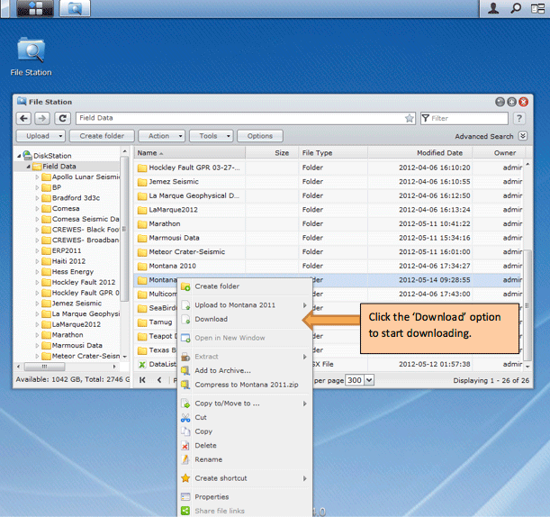
You can access the AGL Datastation using any browser at http://datastation.agl.uh.edu. You can login to the datastation using the login and password that was provided to you. Once you login you can click on the 'File Station' icon that shows up in the browser and go to the concerned directory to see the data. To download the files/directory you can right click on the directory and click 'Download'(see below). The files are usually downloaded in ZIP format. To unzip you can use WinRAR which is available for free at http://www.win-rar.com.
Access using FTP:
You can access using any of the ftp clients. A popular free FTP client is FileZilla, you can download it for free from http://filezilla-project.org . Once you have finished installing the client you can access the server using the following details (refer image below).
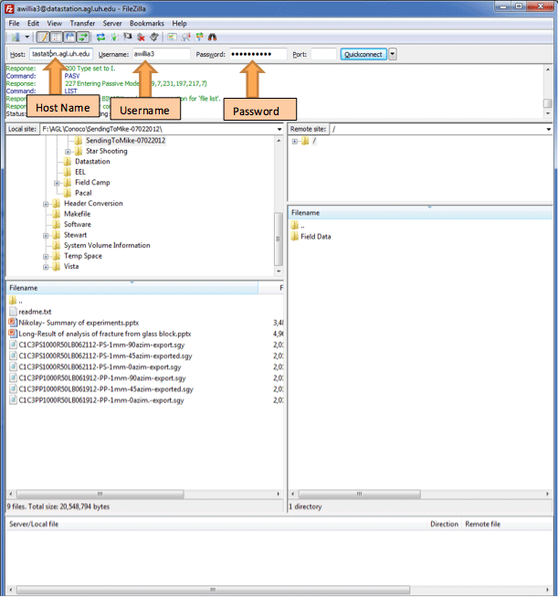
Host name: datastation.agl.uh.edu
Username and Password: The one that was provided.
How do I change my datastation password?
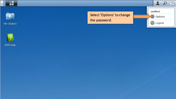
You would be provided with a login and password initially when we create the datastation account. Login into the datastation at datastation.agl.uh.edu using these login details given. Now on the top right click on the 'Option' button(see image below) to access the password change page. You can put in the new password here.
How do I know the amount of time left to download a file/directory?
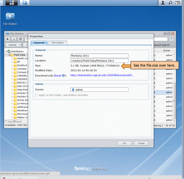
Unfortunately during download the browser does not show how much time is left to finish downloading. But one roundabout way to check the amount of data left to download would be to see the file/directory size and compare it with amount of file that has finished downloaded. To see the file/directory size you can right click on the file/directory and click 'Properties'. See image below for details.